-
Our Community
-
- Our Community About Florence City Newsletter News & Recognition Events & Activities City Calendar Florence Events Center Calendar Chamber Calendar RiverCal Siuslaw Library Calendar Schools Siuslaw School District Lane Community College
- Airport City Projects Directory Doing Business Health Care Resources Library Local Media Rainfall Report Transportation Parks & Trails Directory
- Public Safety City of Florence Police Lane County Sheriff's Office Oregon State Police US Coast Guard - Siuslaw Station Western Lane Fire & EMS Authority Organizations Florence Area Chamber of Commerce Florence Events Center Florence Senior Center Port of Siuslaw Siuslaw Vision
-
- Doing Business
-
Welcome Visitors
-
- About Florence Community Amenities Airport Florence Events Center Library Parks & Trails Directory Public Art Senior Center
- Eat, Shop, Stay & Play Florence Area Chamber of Commerce Move Your Business
- Events & Activities City Calendar Siuslaw Library Calendar Chamber Calendar Florence Events Center Calendar
-
-
Inside City Hall
-
- City Council City Services A-Z Commissions and Committees City Projects Directory Agendas and Minutes Florence News ADA Facility Code of Conduct
- Administration Administrative Services City Manager's Office City Recorder Economic Development Emergency Management Finance Human Resources Municipal Court Urban Renewal (FURA) Utility Billing Florence Events Center Police
- Community Development Building Code Enforcement Planning & Zoning Public Works Airport Parks Stormwater Streets Wastewater Water Media Inquiries
-
-
Helpful Resources
-
- Apply for a Job Apply for a Board or Committee Contact the City Council Contact City Staff Check City Social Media Download Forms & Applications Find a City Code
- Find Transportation Get a Business License Get a Noise Variance Get Email Subscriptions Hold a Special Event Locate City Offices Pay My Utility Bill Pay My Court Fine
- Report a Code Violation Report Storm Related Issues Request a Police Report Request a Public Record Reserve a Park View Bids & RFPs View the Calendar
-
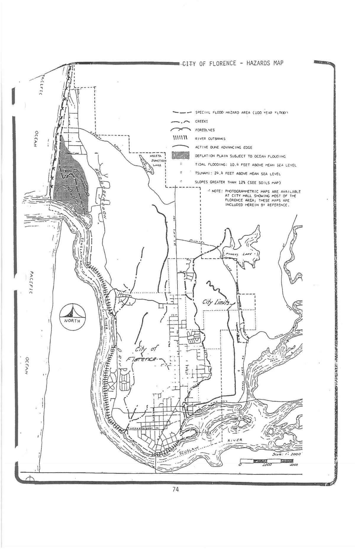
Hazards Planning & Map
Hazards Planning
The City of Florence participates in the Lane County Multi-Jurisdictional Natural Hazards Mitigation Plan (MNHMP). Each participating city and utility has their own annex, along with several utilities. The MNHMP assesses natural hazard risk across Lane County for 10 identified natural hazard types. Approved local hazard mitigation plans allow local governments to be eligible for hazard mitigation grant funds administered by FEMA through the Hazard Mitigation Assistance program. These programs include the annual Flood Mitigation Assistance program, the Building Resilient Infrastructure and Communities program, as well as the Hazard Mitigation Grant Program that is activated following a federally declared disaster that occurs in the state. Local hazard mitigation plans must be reviewed, updated, and approved by FEMA every five years to remain eligible for HMA funds. The 2023-2028 MNHMP was adopted by the Lane County Board of Commissioners on October 10, 2023, via Board Order and it and Annex 4 were approved by Florence City Council under Resolution No. 23, Series 2023.
The Hazards Map
The City's Hazards Map is adopted under the Florence Comprehensive Plan within Appendix 7.
It is one tool used to identify areas where standards are to be applied to eliminate the danger to the health, safety or property of those who would live in potential problem areas and the general public and to protect areas of critical environmental concern; areas having scenic, scientific, cultural, or biological importance; and significant fish and wildlife habitat as identified through:
- Goal 5: Open Spaces and Scenic, Historic, and Natural Resources, and
- Goal 17: Coastal Shorelands
The implementing policies are in Title 10 Chapter 7 Special Development Standards, Title 10 Chapter 19 Estuary, Shorelands, and Beaches and Dunes and Title 4 Chapter 4 Flood Damage Prevention.