-
Our Community
-
- Our Community About Florence City Newsletter News & Recognition Events & Activities City Calendar Florence Events Center Calendar Chamber Calendar RiverCal Siuslaw Library Calendar Schools Siuslaw School District Lane Community College
- Airport City Projects Directory Doing Business Health Care Resources Library Local Media Rainfall Report Transportation Parks & Trails Directory
- Public Safety City of Florence Police Lane County Sheriff's Office Oregon State Police US Coast Guard - Siuslaw Station Western Lane Fire & EMS Authority Organizations Florence Area Chamber of Commerce Florence Events Center Florence Senior Center Port of Siuslaw Siuslaw Vision
-
- Doing Business
-
Welcome Visitors
-
- About Florence Community Amenities Airport Florence Events Center Library Parks & Trails Directory Public Art Senior Center
- Eat, Shop, Stay & Play Florence Area Chamber of Commerce Move Your Business
- Events & Activities City Calendar Siuslaw Library Calendar Chamber Calendar Florence Events Center Calendar
-
-
Inside City Hall
-
- City Council City Services A-Z Commissions and Committees City Projects Directory Agendas and Minutes Florence News ADA Facility Code of Conduct
- Administration Administrative Services City Manager's Office City Recorder Economic Development Emergency Management Finance Human Resources Municipal Court Urban Renewal (FURA) Utility Billing Florence Events Center Police
- Community Development Building Code Enforcement Planning & Zoning Public Works Airport Parks Stormwater Streets Wastewater Water Media Inquiries
-
-
Helpful Resources
-
- Apply for a Job Apply for a Board or Committee Contact the City Council Contact City Staff Check City Social Media Download Forms & Applications Find a City Code
- Find Transportation Get a Business License Get a Noise Variance Get Email Subscriptions Hold a Special Event Locate City Offices Pay My Utility Bill Pay My Court Fine
- Report a Code Violation Report Storm Related Issues Request a Police Report Request a Public Record Reserve a Park View Bids & RFPs View the Calendar
-
Updated Tsunami Inundation Maps Available
The Oregon Department of Geology and Mineral Industries has completed tsunami inundation maps for Florence, Dunes City, Reedsport, Gardiner, Winchester Bay, and surrounding areas. These maps show modeled extents for local-source (Cascadia Subduction Zone) and distant-source (Alaska) tsunami inundation scenarios.
These maps incorporate all the best tsunami science available today, including recent publications by colleagues studying the Cascadia Subduction Zone, updated computer simulation models using high-resolution lidar topographic data, and knowledge gained from the 2004 Sumatra, 2010 Chile, and 2011 Tōhoku earthquakes and tsunamis.
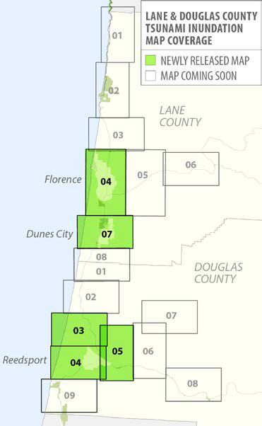
The maps, which provide the basis for the evacuation brochures, contain a wealth of information, including estimated tsunami wave height time series charts and a measurement of the exposure each community has to the various tsunami scenarios: we count the number of buildings that are inundated by each scenario. We hope that the public, planners, emergency managers and first responders, elected officials, and other local decision makers will use these detailed and innovative TIM map products to mitigate risk and to reduce the loss of life and property. Tsunami Inundation Map (TIM) series coverage for Lane and Douglas Counties. Boxed, numbered areas are available as separate publications.
- TIM-Lane-04, Florence
- TIM-Lane-07, Dunes City
- TIM-Doug-03, Gardiner
- TIM-Doug-04, Reedsport
- TIM-Doug-05, East Gardiner
Each TIM publication includes two plates:
- Plate 1 displays five scenarios, labeled as “T-shirt sizes” (S, M, L, XL, and XXL), of the impact of Cascadia Subduction Zone tsunamis that reflect the full range of what was experienced in the past and will be encountered in the future. The geologic record shows that the amount of time that has passed since the last great Cascadia earthquake (312 years since January 26, 1700) is not a reliable indicator of the size of the next one, so the size ranges are intended to fully bracket what might happen next.
- Plate 2 shows tsunami inundation scenarios for two distant-source tsunamis that were modeled and originate in Alaska. These distant tsunamis are not nearly as dangerous as the local ones, as Oregonians will have several hours instead of only minutes to evacuate and the tsunamis themselves are much smaller. For these reasons DOGAMI’s focus is on the big Cascadia events. If the ground shakes for an extended period of time, don’t wait for more warning, evacuate to high ground as fast as possible.
DOGAMI TIM publications can be purchased on CD-ROM for $10 each from the Nature of the Northwest Information Center (NNW), 800 NE Oregon Street, Suite 965, Portland, Oregon, 97232. You may also call NNW at (971) 673-2331 or order online at http://www.NatureNW.org. There is a $4.95 shipping and handling charge for all mailed items.
Contact Information:
Oregon Department of Geology
Ian Madin, Chief Scientist
(971) 673-1542
ian.madin@state.or.us

