-
Our Community
-
- Our Community About Florence City Newsletter News & Recognition Events & Activities City Calendar Florence Events Center Calendar Chamber Calendar RiverCal Siuslaw Library Calendar Schools Siuslaw School District Lane Community College
- Airport City Projects Directory Doing Business Health Care Resources Library Local Media Rainfall Report Transportation Parks & Trails Directory
- Public Safety City of Florence Police Lane County Sheriff's Office Oregon State Police US Coast Guard - Siuslaw Station Western Lane Fire & EMS Authority Organizations Florence Area Chamber of Commerce Florence Events Center Florence Senior Center Port of Siuslaw Siuslaw Vision
-
- Doing Business
-
Welcome Visitors
-
- About Florence Community Amenities Airport Florence Events Center Library Parks & Trails Directory Public Art Senior Center
- Eat, Shop, Stay & Play Florence Area Chamber of Commerce Move Your Business
- Events & Activities City Calendar Siuslaw Library Calendar Chamber Calendar Florence Events Center Calendar
-
-
Inside City Hall
-
- City Council City Services A-Z Commissions and Committees City Projects Directory Agendas and Minutes Florence News ADA Facility Code of Conduct
- Administration Administrative Services City Manager's Office City Recorder Economic Development Emergency Management Finance Human Resources Municipal Court Urban Renewal (FURA) Utility Billing Florence Events Center Police
- Community Development Building Code Enforcement Planning & Zoning Public Works Airport Parks Stormwater Streets Wastewater Water Media Inquiries
-
-
Helpful Resources
-
- Apply for a Job Apply for a Board or Committee Contact the City Council Contact City Staff Check City Social Media Download Forms & Applications Find a City Code
- Find Transportation Get a Business License Get a Noise Variance Get Email Subscriptions Hold a Special Event Locate City Offices Pay My Utility Bill Pay My Court Fine
- Report a Code Violation Report Storm Related Issues Request a Police Report Request a Public Record Reserve a Park View Bids & RFPs View the Calendar
-
Siuslaw Watershed FEMA Floodplain Mapping Project
This page provides a summary of recent progress and upcoming steps for FEMA’s Risk Mapping, Assessment, and Planning (Risk MAP) project for the Siuslaw Watershed in Lane County, Oregon.
Project Overview
The Siuslaw Watershed was selected as a priority area for flood risk updates through FEMA’s Risk MAP program, based on local hazard risks and community interest.
This effort began in 2019 with a Base Level Engineering (BLE) analysis and continues through a series of meetings and map refinements, including recent updates to flood mapping for Munsel Creek.
Recent Activity
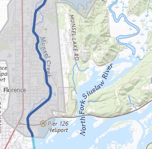
Mapping updates for Munsel Creek are now available for review: Here
| Milestone | Date |
| BLE Maps Released | May 3, 2021 |
| Project Kickoff Meeting | June 10, 2021 |
| Draft Maps Released | September 18, 2023 |
| Flood Risk Review Meeting | November 14, 2023 |
| Revised Draft Maps Released | December 19, 2024 |
| Follow-Up Meeting (Florence & Tribes) | January 24, 2025 |
| Flood Risk Products Released | March 2025* |
| Preliminary Maps Released | Winter 2025/2026* |
| Public Meeting | Spring/Summer 2026* |
| Appeal Period | Late Summer–Fall 2026* |
| Maps Become Effective | TBD |
*Dates are projected and may change.
More Information
If you have any questions about this Risk MAP project, please contact FEMA Region 10 Regional Engineer and Project Monitor Dale Meck (dale.meck@fema.dhs.gov, (202) 285-2671), FEMA Region 10 Risk MAP Implementation Section Chief Marshall Rivers (marshall.rivers@fema.dhs.gov, (425) 381-3773), or Oregon State Risk MAP Coordinator Hannah Fattor (hannah.fattor@oem.oregon.gov, (971) 718-2106).
For meeting materials click here.

